Career story
Stretching more than 2,500 kilometres from Western Australia through the Northern Territory to Queensland, the Australian savannas are tropical grasslands where distance is measured in hours and horizons.
On a hot day, fire can outrun a vehicle. In landscapes this vast, knowing what has burned, what is burning, and what might burn next can be the difference between a planned, cool‑season burn and a late, intense wildfire.
For academic Rohan Fisher, that situational awareness increasingly comes from above — satellites that turn daily imagery into practical, on‑the‑ground decisions.
His research explores space technology, culture, and one of Australia’s oldest land‑management practices: fire. An inspiring instance of how data from space helps elevate Aboriginal and Torres Strait Islander knowledge on the ground.
Rohan's career sits at that productive intersection: space technologies turned into everyday tools, and science practiced in partnership with Indigenous leadership.
Delivering environmental and climate benefits on a continental scale
Rohan has over 30 years of experience working with satellite data and Geographic Information Systems (GIS). He began his career at CSIRO in Canberra before joining the Northern Territory Government in Alice Springs and Darwin.
For the past 20 years, he has served as a Research Fellow at Charles Darwin University (CDU), specialising in the application of GIS and remote sensing tools for natural resource management, governance in Eastern Indonesia, and savanna fire management in Northern Australia.
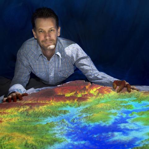
Rohan is currently CDU's Director of the Landscape Knowledge Visualisation Lab, which focuses on the projection of augmented landscape models. His work uses appropriate tools to create dynamic spatial holograms of Country that facilitate clear communication of complex human ecological problems and local knowledge solutions.
Exploring bushfire research through satellite data
In the early 2000s, Rohan was among the few Australian researchers and land managers who realised satellite imagery could do more than document fire scars after the event — it could actively support fire management.
"The need was growing. Savanna landscapes have always been prone to fire and have become increasingly more frequent and more intense," Rohan shares.
That realisation helped spark a practical innovation: North Australian Fire Information (NAFI), a website launched in 2003 and hosted by CDU.
What began as regularly updated maps of recently burnt areas has grown into a widely used platform showing active fires and burn patterns across the rangelands.
Two decades on, NAFI underpins fire management across around 80% of Australia and supports from planning and response to implementation and reporting.
Complimenting Indigenous knowledge systems
But Rohan’s work is not a story of technology replacing tradition. It’s about technology complimenting Indigenous knowledge systems at a scale that modern conditions demand.
Over the past 20 years, proactive landscape burning has been revived across northern Australia, with Indigenous community-based ranger groups playing a central role.
"Customary knowledge remains the foundation, while helicopters, remote sensing, and satellite mapping make it possible to coordinate burning across enormous distances," Rohan points out.
"In this reconfigured practice, satellites provide the broad, timely view; Indigenous land managers bring the deep cultural and ecological understanding that guides when and how fire should be used on Country."
According to the researcher, collaboration — built on respect for the sophistication of traditional knowledge — has been a major reason for the collective success. And the results appear to be striking.
"Effective fire management over the past two decades has reduced the annual average area burned by an amount larger than Tasmania," Rohan adds.
Career journey
Completed a Bachelor of Applied Science from the University of Canberra.
At CSIRO, worked on the first-ever Australia wide Earth Resource Satellite that studied land cover change across the country and lead to a publication titled “Looking Back," which showcased the utility of satellite imagery.
Worked at the Northern Territory Government in Darwin and Alice Springs on the first national land cover change assessment program as well as with the pastoral sector mapping land types with Landsat.
- With Charles Darwin University, Rohan began a decade and a half working on projects in resource poor regions of Eastern Indonesia.
- These projects ranged from supporting the mapping and analysis of savanna fires, developing geo-spatial tools for assessing access to maternal and neonatal health as well as mapping the impacts of small-scale mining.
- Rohan's focus on all of these projects was not to do this mapping work but rather transfer the remote sensing and spatial analysis skills to local experts.
- He believes this was the beginning of his journey focusing on a ‘people-first’ space tech approach — simple, free, open source and appropriate.
- Started to support remote sensing work monitoring the fire regimes of Northern Australia with NAFI at CDU.
- Worked with Indigenous ranger groups across northern Australia, building skills in using satellite data for large landscape scale fire management.
Named the 2017 Territory NRM Researcher of the Year.
Recipient of the AFR National Higher Education Award in the Education Technology Category. Rohan was recognised for his work translating satellite information about fires into a 3D interactive format that allowed Indigenous People to take the leading describing their fire knowledge for joint planning.
Established the Landscape Knowledge Visualisation Lab at CDU, which bridges the gaps between science and traditional landscape knowledge systems.
Completed his PhD on Projection Augmented Landscape models and fire simulation.